

 (Easy – 3 km; 1.5 hours return)
Bright’s most popular walk takes you past a small canyon carved by the Ovens River and amazing water races carved by the hands of early miners.
Enjoy the ever changing river in all seasons and watch for birdlife and wildflowers especially in spring.
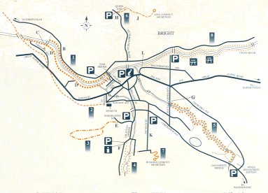
A – Start at Star Bridge or the end of Riverside Ave. The northern track (B) which has steep steps and may be difficult for people with limited mobility
C – For an easy loop, continue past the suspension bridge to the railway bridge and return along the Alpine Rail Trail.
D – Along the southern bank are many deep and narrow water races, cut by hand through solid rock. The deeper the race, the further the mining site was from the river.
NB. Caution – cliffs and steep banks.
![]()
(Easy)
This popular bike and walking track is ideal for families with pushers. It officially starts at the “old” Bright Railway Station (now the museum) but you can join or leave this converted railway line at many different places along its length to create your own walk route.
![]()
(Medium – 2.5 km; 2 hours return)
E – The best place to park is near the school on Hargreaves Street. Look for the signposted start of the walking track where the eucalypt forest meets Hargreaves Road. In spring, look for native orchids on walks 3 & 7.
![]()
(Easy – 0.5 or 1 km 05 or 0.75 hour return)
Stroll around one or both of these reservoirs. The first dam was built in 1892 and the second in 1916 to provide a permanent supply of water to the town, railway station and trains.
The reservoirs no longer provide water to Bright but they do offer a peaceful place for walking. Enjoy watching and listening for wildlife in the former reservoirs, now home to platypus, tortoise, fish. frogs and yabbies. Try your luck at catching a trout.
Lots of fungi grow among the leaf litter in autumn.
 Try a spotlight walk here at night. Bring a strong torch and warm clothing.
F – Follow the walking track that leads from the Information Shelter then follow the signs to circle one or both reservoirs.
![]()
(Easy – 2.5km: 1.5 hours return)
Explore the quiet reaches of Morses Creek between the caravan park and Dougherty Bridge. Mines Department Battery near Dougherty Bridge was erected as recently as 1956. This five-head stamp battery provided quartz crushing facilities for gold prospectors until it closed in 1994. The battery and forge is opened for viewing during festivals and school holidays.
G – Start at either Hawthorn Lane or Dougherty Bridge, follow the track along one side of the creek to a bridge then complete the loop via the other side of the creek.
(Medium – 3 km; 2 hours return)
H – Drive to Quinn’s Gap up Mt Porepunkah Road. Park a short way up gravel track where the walking track turns right, off the gravel track. The steady climb rewards you with views of Mt Feathertop, Mt Fainter, and Mt Bogong. the highest peak in Victoria.
J – Eucalypt forests of Peppermints and Box cover these lower slopes of the Victorian Alps. Crush a leaf and smell it to discover which is the Peppermint. Look for evidence of wombats or wallabies.

![]()
(Medium – 1.5 km; 1 hours return)
K – Park here along Deacon Ave for Huggins Lookout Walk. Walk along Deacon Ave and Zivan Court to the start of the Walking track. Return the same way.
![]()
(Easy -3 km: 1.5 hour, return)
Stroll along the banks of the now picturesque Ovens River and reflect in its past. Once a hectic noisy scene of gold digging and dredging, it is now a place for relaxation and quiet strolls.
Stripped of its gold and plant cover, the land on both sides of the river had been left in a severely degraded state, even though the companies had promise to replace the topsoil. In 1916 this was the site of the first experimental pine plantings to reclaim a dredged area. This test planting showed that Radiata Pine survived well and other dredge tailings, began being restored by planting them with Pines. Their success led to the establishment of commercial Pine Plantations on non-mined areas.
The Cherry family name is still a common one in the area.
L – Start near the Water Slide on Mountbatten Ave. Follow the southern bank of the river to the suspension bridge and return along the northern bank. This walk can also be started at the parking area where Hawthorn Lane meets the river.
![]()
![]()

(Easy – 5 km: 2 hours return)
Walk from Bright to Wandiligong along picturesque Morses Creek. As you saunter up and down the old dredgings and past its little rocky gorges, rapids and quiet secluded holes, contemplate how important the local creek and river have been and continue to be to the region. Native eucalyptus shade much of the track.
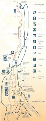
M – Start at Dougherty Bridge Bright
![]()
(Easy -1 km: 1 hour return )
Park at either Alpine Park or Royal Bridge and complete this circuit of Wandiligong’s historic sites and buildings, imagining it filled with the 3000 people that once lived here.
N – Alpine Park has been a recreation reserve since 1877. The original 1884 pavilion was recently rebuilt.
P – The first section of the impressive Wandiligong School was completed in 1877. It had to be extended to cope with 300 students during the gold era.
Q – First official Post Office built in 1885, replacing, General store and Post Office on adjoining site.
![]()
(Easy – 2km, 1 hour return)
Starting at either Alpine Park or Royal Bridge. This loop takes you through the goldfields of Wandiligong. The Dig- area has been subjected to almost every type of mining. The first diggers in 1860s sluiced for alluvial gold with gold pan, sluice box and cradle. Deep mine shafts were then sunk to locate deep leads of gold bearing rock. Heavy machinery in the form of the Wandiligong Number 1 Dredge worked the area between 1905 to 1914.
R – This area was worked by Chinese and contained a small settlement of houses, shops, flower and vegetable garden and a Joss House.
S – The Wandiligong Number 1 Dredge worked over the old alluvial diggings between the Hall, Post Office and Hotel, leaving the whole area severely degraded.
T – Adit. (Mine entrance) Collapsed and filled with water
U – Stephens Water Race. This channel carried water to the water wheel in Stephens Mill.
![]()
(Easy – 2km: 1 hour return)
Explore the quiet back lanes of Wandiligong to Williams United Mine and return past the Hotel. Still a great pub for a drink and chat – if only the walls could talk!